River of Many Stories
Follow Michael Lanza's journey as he canoes down New Zealand's stunning Whanganui River, learning the stories of the area, as well as its cultural significance to Māori.
Follow Michael Lanza's journey as he canoes down New Zealand's stunning Whanganui River, learning the stories of the area, as well as its cultural significance to Māori.
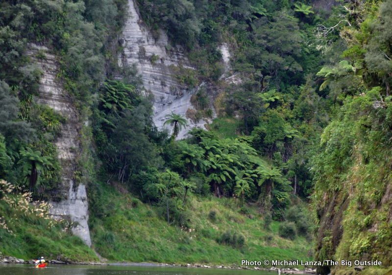
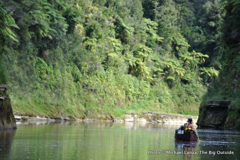
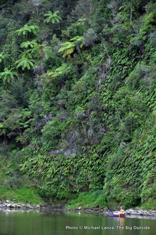
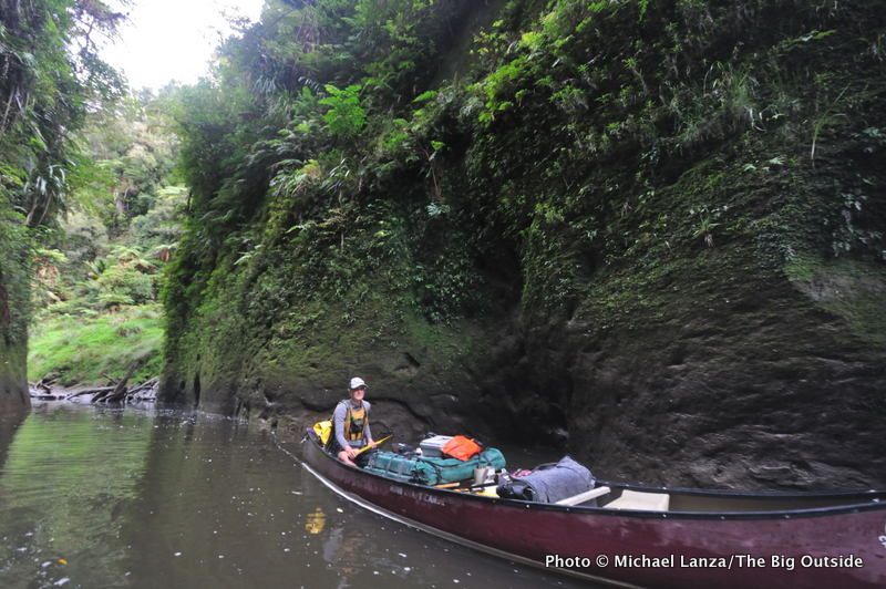
Within minutes after launching our canoe into the chocolate-brown and, at the moment, tranquil Whanganui River, in the southwestern corner of New Zealand’s North Island, I begin to get a sense of why the native Maori people believed that every bend in this striking waterway had a mauri, or “life force.” We’ve entered a nearly unbroken gorge of sheer sandstone and mudstone cliffs soaring up to 200 feet straight out of the water, draped with jungle-like foliage in infinite hues of green. Cicadas buzz and rattle almost deafeningly. Ribbon waterfalls pour in straight, pencil-thin lines down walls so oversaturated that they weep tears from every fern and leaf.
The Maori are right: this place is very much alive.
Also within minutes, my partner in this canoe, whom I met just an hour ago, begins pointing out birds such as tui and kingfisher, and plants like the toi-toi, with its long stalks and large, cream-white seedpod heads. She identifies trees like the punga, with its giant fronds, and the thick-trunked totara sprouting from the cliffs, while casually schooling me in Maori terms and history on this river of many human stories and ghosts.
Mereana (“Merayanna”) Matekingi Lewis, a woman in her 60s with waves of gray-white hair and multiple laugh lines joining like the tributaries of a river at the corners of her eyes, is part Maori, and the Whanganui is her family “owa,” or river. She is descended from the people who once carved canoes from those fat totara trunks and plied these waters for innumerable generations, harvesting wild edibles and herbs and scattering their tales and legends liberally along these riverbanks. She liberally spices conversation with Maori terms such as “waka,” meaning “canoe.”
By pure luck, I’ll spend the next three days on the Whanganui sharing a canoe with my own personal historian-naturalist.
Mereana and I are the clients of Laura Wallis, a 22-year-old guide with a local outfit called Canoe Safaris. Laura is leading us down the pristine, 54-mile-long stretch of the Whanganui from Whakahoro to Pipiriki. Mostly within Whanganui National Park, the Whanganui River offers one of the most beloved multi-day wilderness trips in a country known for its wealth of adventure offerings, because this trip hits a somewhat rare trifecta: unusual natural beauty, deep and fascinating human history, and the accessibility of being within the abilities of people with basic paddling skills (including families, of which we’ll see plenty at campsites). The section we’re traveling comprises the bottom segment of the Whanganui River Journey, a 90-mile, five-day canoe or kayak adventure from Taumarunui to Pipiriki that is the only water-based trip listed among New Zealand’s vaunted Great Walks.
The Whanganui River holds such special reverence, in fact, that it has been granted the same legal rights as every New Zealand citizen. On Aug. 30, 2012, an agreement was reached giving the Whanganui a legal identity—a first in the world for a river. According to the New Zealand Herald, the river “will be recognized as a person when it comes to the law.”
Dipping my paddle into waters brown from recent heavy rains, and steering our canoe through the first of more than 200 class I and II rapids we will navigate over the next three days, I’m looking forward to getting to know this river-personage better.
From its headwaters on the slopes of the active volcano Mt. Tongariro ( which i hiked a day before embarking on this trip), the Whanganui River meanders 180 miles (290k) through thickly forested hill country—what Kiwis call “bush”—to the Tasman Sea at the town of Whanganui. It is the country’s third-longest river and longest navigable one. Over the ages, the Whanganui and its tributaries have sliced downward through mudstone, or “papa,” creating gorges riotous with plant life in one of the rainiest places on the planet.
But more than any other New Zealand national park, Whanganui’s history is intricately interwoven with the history of human settlement here.
For at least 600 years before Europeans arrived, the Whanganui Valley was one of the most densely inhabited areas on the island. Numerous Maori villages, or kainga, and family settlements called marae existed along its banks; the Maori fished and traded all along the Whanganui and some of its tributaries. They call the river “Te awa tupua,” and consider it a “taonga,” or special place. In Maori legend, every bend and rapid has a “kaitiaki,” or guardian who protects that spot’s mauri.
After colonists settled here, a major trading post grew up at the river’s mouth. Alexander Hatrick started the first regular steamboat service in late 1891, after having the paddle-steamer Wairere shipped in sections from London and reassembled here. His boats provided mail and freight to Maori and settlers along the river until the construction of roads in the 1920s, though the steamboat business continued until 1958. The New Zealand government encouraged citizens to settle and farm the valley in the 1930s, but the last of those farms were abandoned by the early 1940s, the people fleeing the remoteness and hardscrabble lifestyle.
In 1986, New Zealand established Whanganui National Park, which now safeguards one of the largest remaining tracts of podocarp and hardwood lowland forest on the North Island, an alphabet soup of greenery: trees like the kamahi, tawa, rimu, mÄ«ro, tÅtara, kahikatea, mataÄ«, and nÄ«kau palm, and ferns ranging in size up to the 100-foot-tall mamaku. The park and river provide rare habitat for numerous species, including the whio, or blue duck, the North Island’s largest population of brown kiwi (numbering an estimated several thousand birds), 18 kinds of native fish, and eels, lamprey, koura (freshwater crayfish), and black flounder.
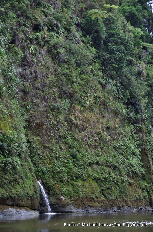
The bush grows so thickly on the cliffs that vegetation often hangs out over the river. We paddle past myriad dark, vertical slots cutting into the walls, too deep for us to see where these big cracks end, and too narrow to probe into with our canoes. Usually, we can only hear a waterfall inside those slots, not see it, the view inside blocked by close, curving walls. Water pours from these cracks as if from a jug, filling the goblet of the river.
But then, late on our first afternoon, we come upon a side canyon that’s several feet wide on river right, and Mereana and I nose our canoe inside it. About 30 feet in, we tie the canoe off to a rock and climb up onto a wide ledge, walking over the slick stone and through the shallow stream draining this slot canyon for another 30 feet, stopping at a waterfall rising before us. It’s deeply shaded and at least 10 degrees cooler than the temperature in the sunshine on the river. Mosses hang from the slimy walls like long, unkempt hair.
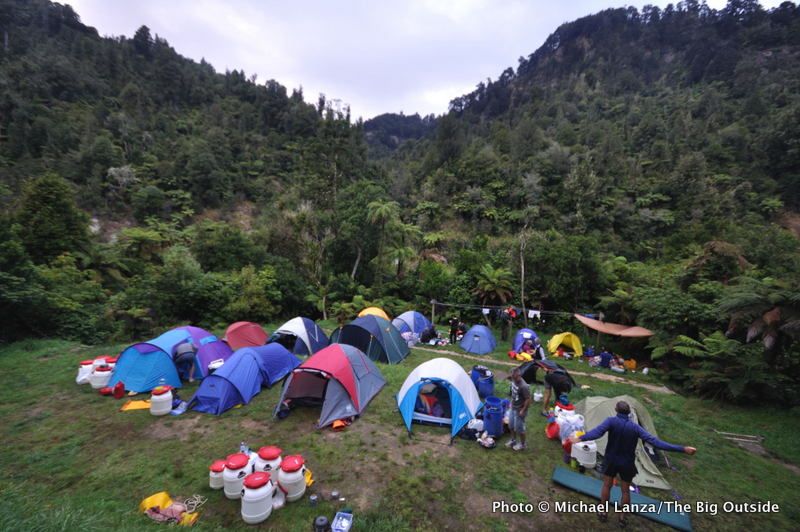
Back on the river, minutes beyond that side canyon, we reach John Coull Hut. The hut typically fills up—and will tonight—so we choose instead to pitch tents in a nearby, grassy clearing, where by nightfall a small tent village materializes. At dusk, kids run around the camping area. The Whanganui is definitely popular, but as we’ll discover over our three mid-summer days out here, parties disperse on the water, so we see hardly any other canoeists while paddling.
Still, we want to get ahead of the crowd. So in the morning, we rise early and get on the water just after 8 a.m. Mereana says she heard a morepork, New Zealand’s native owl, overnight; Laura heard a kiwi. The New Zealand bush comes more alive after dark than it is during the day.
Just before noon on day two, we take out at Mangapurua Landing for the 40-minute uphill hike to the Bridge to Nowhere. A concrete structure spanning the deep gorge slashed into the bush by Mangapurua Stream, it was built in 1935-1936, financed by the New Zealand government. The objective was to eventually build a road to settlements in this valley that had been opened up to World War I veterans by the government, hoping to encourage the development of agriculture. But life was hard, and the land not suitable for farming. The last settlers left after a flood in January 1942
The trail climbs bluffs a few hundred feet above the river, through dense bush with big punga and other trees sprouting from a nearly vertical wall. We step from the cool shade of the bush onto the bridge and into the sun-blasted heat.
Gazing down a few hundred feet into the gorge, I’m reminded of other wild lands I’ve explored, like Hells Canyon in the United States, where government-supported efforts to bring in settlers ultimately failed. The Bridge to Nowhere, an anomalous structure in the middle of wild country, connected to no road or community, stands as a monument to the flawed presumption that we can always tame the wilderness. Lucky for us that this effort failed, too, or this trip might be a very different experience.
The Bridge to Nowhere offers a lonely metaphor for the long, varied, and sometimes-turbulent history of human presence on the Whanganui River—demonstrating how nothing stays constant, whether seen from our relatively short historical perspective or the longer view of natural history. Settlers introduced non-native possums and domestic goats to New Zealand, which have devastated the populations of many native birds and other animals along this river. So the Whanganui River’s story tells of the successful preservation of a special, historical place, but also a cautionary tale about the capacity for humans to unintentionally mar the natural world—if not forever, then for a very long time.
And the only true constant, of course, is this river.
As someone who spends much more time in mountains than on a river, it takes me a little time to recalibrate my senses to a water trip. But slowly, I start getting into the rhythm of it, seeing not just continuous green walls but the incredible complexity of vegetation on the cliffs. Mereana and I paddle close to the bluffs and touch the plants hanging from the walls, everything as waterlogged as a sponge in a kitchen sink.
On our second day, we paddle through more fun, bouncy wave trains and past more waterfalls than we can count, and peer into a few tributary slot canyons. A pleasant rain shower briefly cools us off on an otherwise warm, sunny day. In the dead heat of mid-afternoon, we pull the canoes onto a muddy riverbank and take a cooling dip in a placid stretch of the Whanganui.
Mereana grew up in New Zealand, but now lives in Perth, Australia. In Maori, Mereana means “fighting girl,” she tells me, adding with a hearty laugh, “Remember that!” Her upper left arm bears a tattoo, representing her marae, inscribed by an uncle when she was 11 years old.
This trip down the Whanganui, birthplace of her ancestors, is clearly very meaningful for her. Her family came from the lower Whanganui River, she says, and one grandmother came from a spot about halfway upriver. This gives her an affiliation with all of the “sub-tribes” on the river, meaning she’s related to anyone who comes from here, and thus, by tradition, has the right to walk on any marae on the Whanganui River. It is considered trespassing to enter a marae without permission, like entering someone’s home without being invited in, as she explains to me.
So it is with great solemnity that, at the end of our second day, when we take out across the river from the Bridge to Nowhere Lodge and a campground where most parties spend the night, Mereana leads Laura and me on a tour of Tieke Kainga marae, about a hundred feet above the river.
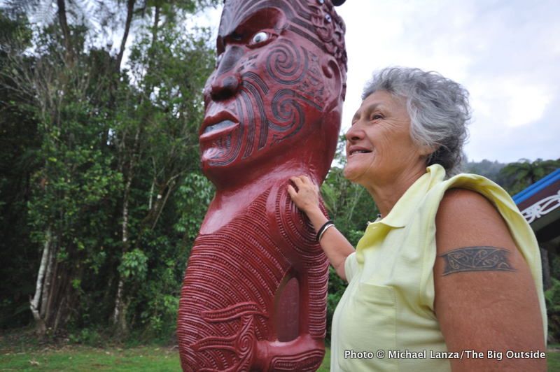
We walk quietly into the grassy courtyard of this ancient village and religious spot. Thick bush rings the marae on all sides but the front, which faces downhill, toward the river. A few small buildings occupy the site, including a meeting hall and a one-story home. No one is here, but Tieke Kainga is probably still used by Maori families for weddings and funerals, Mereana tells us. A red totem several feet tall, carved from one log of a totra tree and topped by a large head with a wildly painted face, stands in the middle of the courtyard area. The head on top represents the mountains at the source of the Whanganui, and the characters on the totem tell the story of the tribe’s whakapapa (pronounced “fakapapa”), or genealogy. Symbols of river waters spill from the totem’s base.
In early evening, Laura prepares a delicious dinner of steak and potatoes with vegetables and an orzo salad. Our guide—whom I have yet to see wear shoes on this trip, including on the hike to the Bridge to Nowhere—has proven an able backcountry chef, feeding us a first dinner of pasta with chicken, vegetables, and salad, and breakfasts featuring pancakes with fresh blueberries and eggs, toast, sausage, bacon, and home fries. Laura also charmingly uses many wonderfully evocative Kiwi colloquialisms, like saying “heaps” when she means “a lot,” as in “you’re taking heaps of photos;” and “wee” for “little,” as in “we’ll stop at that wee sandy bit.” She says this in the canoe while nodding toward a sandy beach, pronouncing it, “a wee sandy bet.”
After dinner, Mereana invites us to join her laying out our sleeping bags for the night on the veranda of the small house.
Sitting on the grass above the river, Mereana, Laura, and I talk until well after dark, when we hear a morepork in the tree behind us. We shine lights into the tree and see this owl-like bird perched there. Throughout the night, we hear the morepork making its well-known, loud screeching sound, but also its rarely heard “morepork” call.
On our last day, a few hours of paddling downstream from the marae and Bridge to Nowhere Lodge, we reach the final and most notorious wave train on the Whanganui: Autapu Rapid. Google “Whanganui River” and you will read many nail-biting tales of canoeists flipping in it. We have been talking about it since putting onto the river the first day. Laura tells us bluntly that at the river’s current, high level, “about 95 percent of canoeists get swamped by the waves.”
Staring at it, I figure it’s class III. But Laura also assures us that, if we did flip, we would merely bob safely through the waves into the gentler water below the rapid and easily swim to the shore.
I ask Mereana whether she wants to run it, and she enthusiastically chirps, “Of course!” With attitude like that from my partner, there’s no way I can back out.
We go for it, digging furiously with our paddles, trying to keep the bow straight down the piles of choppy, roiling water. But first one wave crashes over the gunwales, then more. As our canoe lists hard to starboard on its way to capsizing, the last thing I see and hear before going under is Mereana—the “fighting girl”—catapulting out of our canoe, laughing uproariously.
See my other stories and images from adventures in New Zealand:
Super Volcanoes: Hiking the Steaming Peaks of New Zealand’s Tongariro National Park
Off the Beaten Track in New Zealand: Trekking the Rees-Dart in Mt. Aspiring National Park
Into the Mystic: Sea Kayaking Doubtful Sound In New Zealand’s Fiordland National Park
THIS TRIP IS GOOD FOR canoeists and kayakers with experience paddling swift rivers. Novices paddle this class I-II river, but some of its more than 200 rapids are challenging, depending on the water level. Autapu Rapid, the last major one before Pipiriki, is notorious for swamping canoes, although it’s a wave train that people safely swim through, and it can usually be avoided entirely to river right.
Make It Happen
Season September to May.
The Itinerary The three-day, 54-mile trip on the Whanganui River begins at Whakahoro and ends at Pipiriki. The entire Whanganui River Journey, a 90-mile, five-day excursion from Taumarunui to Pipiriki, is the only water-based adventure listed among New Zealand’s vaunted Great Walks.
Getting There A shuttle is required to the put-in at Whakahoro or Taumarunui, and from Pipiriki, a minimum one-hour drive from the town of Ohakune.
Huts/Camping On the three-day trip, spend your first time at John Coull Hut (bunkrooms or camping) at mile 23, and second night at Bridge to Nowhere Lodge or the campsites adjacent to it or across the river, at mile 41. Reservations are required for huts and campsites from Oct. 1 to April 30, and can be made at DOC offices or at booking.doc.govt.nz/Menu.aspx?sg=WJY; there is a per-person nightly fee. During the off-season, purchase hut tickets prior to your trip; camping is free then.
Map and Guide The Whitewater NZ “Guide to the Whanganui River,” $9 NZ in DOC offices and stores, or $10 NZ (including postage) from Whitewater NZ, +64 27 486 6994, rivers.org.nz/whanganui-guide.
Did the 3-day guided canoe trip down the Whanganui river with Phil and Simon as our guides. Even though all of us were first-time canoeists and a few of us were non-swimmers, they looked after us very well and were amazing at teaching us the skills we needed to keep ourselves safe. The...
Mark Loh
A couple of good mates decided we'd do this trip some time ago and Canoe Safari's helped make it happen. Alex, Bailey, Lesley and Canon our guides / hosts were absolutely amazing. Scenery was stunning - seems like little has changed on the landscape in hundreds of years... still...
Hawkdwn
A friend and I, both in our 70s, did the 3 day 2 night Whanganui River canoe trip run by Canoe Safaris in March 2025, staying at their Lodge the previous 2 nights. It was exceptionally well organized and great fun. Never once did we feel in any danger. The 2 guides were excellent, teaching us...
Jonathan Wake, New Zealand
Had the most enjoyable trip in my life. Took the 4 day canoe safari down the Wanganui river. We thoroughly enjoyed it, couldn't have asked for better guides, Erin and Jordan. Their knowledge and expertise was invaluable. The scenery was out of this world, at times we felt as though no one...
Sharon Gamble
SIMPLY SENSATIONAL. Just completed the 3 day trip. Our guides Wilson and Gregor were fantastic. Cool, clear, calm (even when I tipped the wife out of our canoe). Always felt safe, always felt informed. The food was sensational. From the time we were greeted to the time we departed, I was very...
Warren J, Christchurch, NZ
We did a family 4 day guided canoe trip, it was absolutely amazing. Very professional, our guides Morgan and Aiden were very knowledgeable and friendly. The food was way above expectation and the memories we have made will be with us forever. Highly recommend.
Leeann Morgan
This was the best family trip ever! Three course meals, a wealth of knowledge from our awesome guides, and no devices, were just three reasons we would highly recommend this adventure. Phil and Simon were amazing guides and worked from the moment we were collected for our trip to the moment we...
Richard Beechey
We had a magic 4 days on the Whanganui thanks to Kirsty Phil Keira and Jackson. The equipment, food, guiding and training were faultless. Phil's instruction was enough to make us confident on the river without overloading two novices and Keira's and Jackson's enthusiasm and...
Larry B, New Zealand
We had a brilliant trip on the Rangitikei River with this amazingly organised and friendly company. Kirsty and Phil looked after us so well- from their (well Kirsty's) first response to our enquiry to waving us off at the end of a magnificent and well supported two day trip. The tuition and...
Kate Brennan, New Zealand
We went on the four day canoe safari and absolutely loved it! Amazing scenery, and great service. Aidan and Morgan really went the extra mile to make sure everyone was happy and comfortable. Food was just like the comforts of home! We were very well looked after, and felt safe on the...
Nicola Johansen